Tuesday 30 October 2012

Ghorepani

Shortly after we took occupation of our newly built house on Simbithi Estate, we discovered that, in addition to being homeowners, we were the proud new proprietors of a burgeoning dagga plantation.  When I asked a friend in the building trade where he thought it had come from, he said it was not uncommon to have dope growing in the gardens of newly built houses.  It is the builders themselves who apparently sow the seed when they carelessly discard their joints.  Naturally we never harvested any of it but for a time it was the biggest concentration of weed I’d ever seen.

Until, that is, I went to Nepal.  The groves of marijuana that thrive in the Ghar Khola Valley are so dense and prolific that if this biomass were to spontaneously combust for some reason, the only thing which wouldn’t get high would be the mountains themselves.  The weed, so far as I could tell, is traded with dealers in Kathmandu, sold independently to trekkers and even used by the lodges to spice up the local cuisine (by request naturally).  There was a lot of other vegetation too – fantastic forests of Rhododendron and blue pine, exquisite orchids and other species the names of which now elude me.

A friend who’d done the circuit in 2010 told me that this side of the mountains (Chapter 2 as I referred to it earlier) had not really impressed him.  “It’s not the real Himalaya and is too much like the hills on the outskirts of Durban,” he said.  While I don’t agree with him, I use it now as a provocation to define the unique differences between the two sides of the mountain range.

Chapter 1, the trek from Syange to Jomsom was, at least for me, less a place than it was a state of mind.  As an impressionable 9 year old, I remember reading and re-reading Herge’s “Tintin in Tibet”.  The comic strip made me drunk with dreams of my own Himalayan adventure.  A small rocky hill behind my grandparent’s house in Salisbury served as the ideal prop for this fantasy.  After school I would shoulder my canvas rucksack and head out on my own imaginary summit missions.  Though the summit of Annapurna is invariably tackled from the southern side of the circuit, the proximity to those great mountains made Chapter 1 a fruition of those childhood fantasies.  This was the world that had seduced the likes of Bonnington, Lachenal, Herzog and other intrepid climbers.  It was the world of Yak trains, high mountain meadows and the exotic animals that graze upon them.  It was also the world of Tibet, or at least of Tibetan influence – a fair facsimile for the vivid portrayals which Heinrich Harrer so beautifully captured in his classic book, “Seven Years in Tibet”.  If the area wasn't in the flight path of such massive change, I would have no problem describing it as a sort of Shangri La. 

Chapter 2 on the other hand – the stretch from Tatopani to Nyapul – was an anthropological immersion in the ancient ways of a people.  It was about charming bucolic hamlets, ancient rice terraces and cobbled walkways.  Of people living cheek by jowl with their animals – goats, cattle, chickens, ducks and buffalo – of the sweet homely smell of dung.  For 5 days, it was as though we had been parachuted into an exquisite diorama, the life’s work of the world’s greatest anthropologist.


These young guys were pretty good volleyball players - though the ball kept disappearing down the slope


*
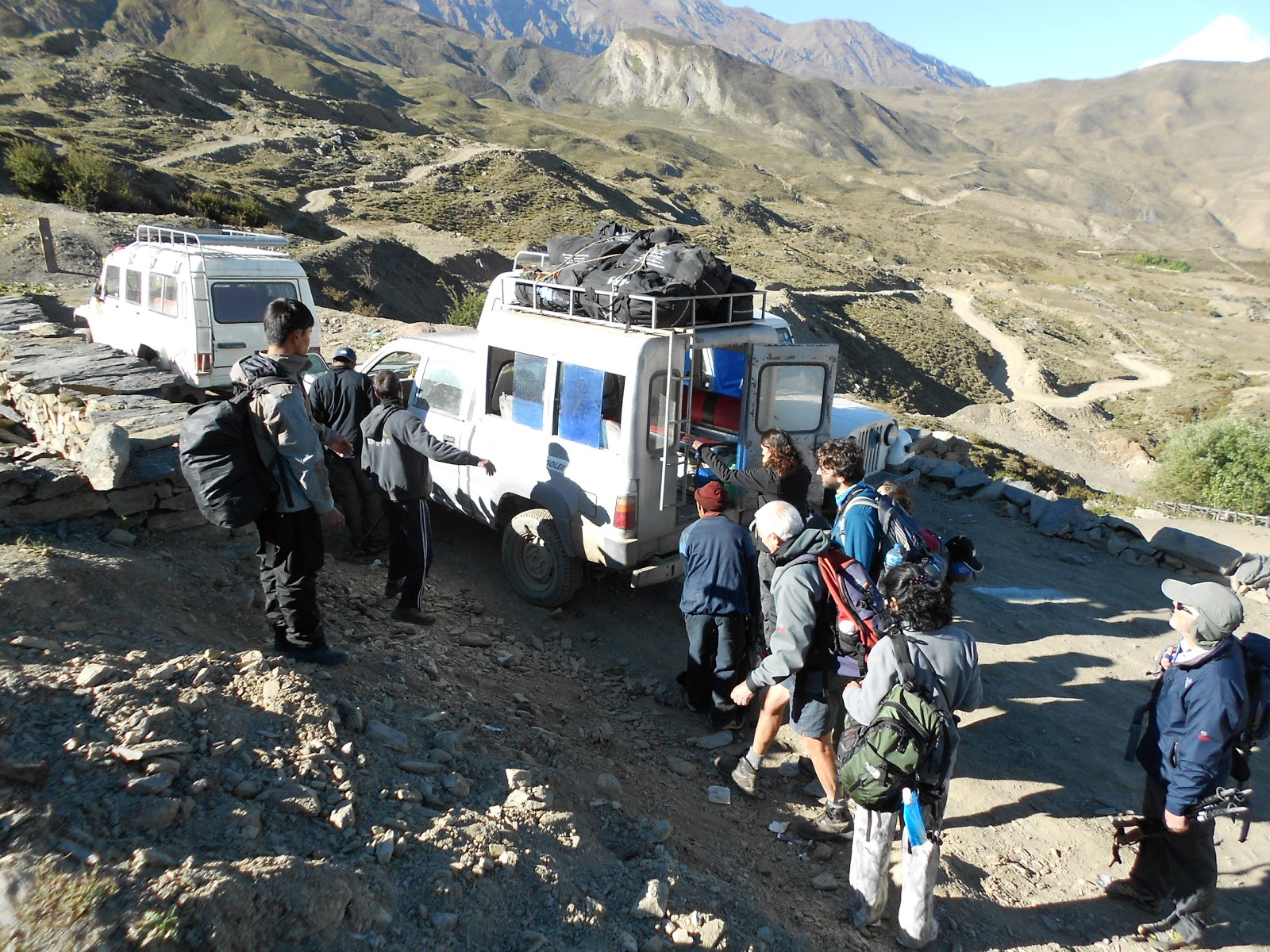
As we headed up the valley, we heard the telltale whup-whup of helicopter rotors echoing in the distance off the valley walls.  We watched as the red and white Bell Ranger chopper descended in every tightening circles into Tatopani.  Ten minutes later, we were on tenterhooks as the machine laboured sluggishly up the Ghar Khola.  The six of us raced to the top of a nearby shrine and raised our poles in final salute.  Hemmed into the valley without a cell phone signal, it would be nearly three days before we could learn of Sandra’s condition.

Two hours later we stopped for lunch at a teahouse in Ghara (Nepali for “beehive”).  It was a tiny shack with a lovingly maintained garden and a God’s eye view of the Kali Gandaki River.  The air throbbed with the humming of bees and we ate piping hot cornbread and freshly harvested honey.  Raj, who had stayed behind to supervise the evacuation caught up with us there.  He had been trekking hard uphill for the last three hours without a break.  That night we slept half way up the valley in a tiny village called Shikha.  We were the Lodge’s only guests so each was assigned their own room, a fantastic luxury even given that mine had a resident chicken.  The view from my window offered sweeping views of the valley through which we’d climbed and was a great vantage point to observe the unhurried ebb and flow of village life.  After dark we climbed up to the rooftop and gazed up at the Milky Way.  To see the night sky like this is becoming an increasingly rare treat these days and with the moon still to rise, it looked a lot like someone had spattered the black ceiling of space with a white paintbrush.  

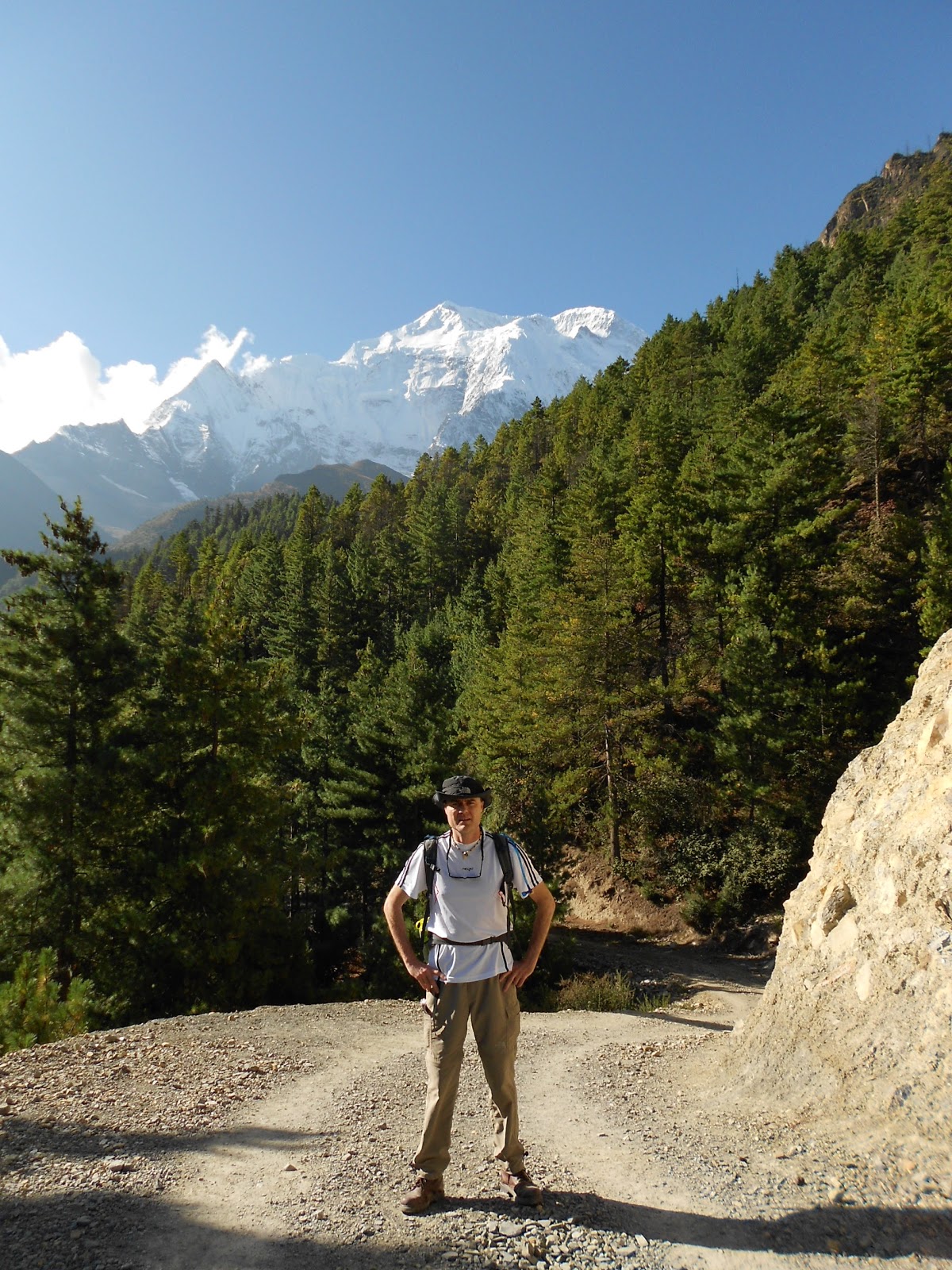
The following day, we continued our ever-steepening climb through the valley.  Here, women in traditional dress were harvesting crops and feed for their animals.  There, men and boys as young as 13 were hefting massive head loads back to their primitive storage areas.  With the seasons quickly changing, the community was locked in a unified effort to lay up enough food for winter.  It was late afternoon when we arrived in the tourist hub of Ghorepani, a village arranged precariously around the intersection of two valley ridges and which sits in the lee of the famous Poon Hill.  

We arrived in Ghorepani as the trekking season kicked into high gear.  The area (2860 metres) is immensely popular with people who don’t have much time to spare and who aren’t keen on the hardships of altitude.  A 4-day circuit out of Pokhara affords tourists good exposure to these exquisite valleys and the mandatory dawn patrol up Poon Hill offers one of the region’s most spectacular Himalayan panoramas.  The age profile of trekkers here is considerably older than it is on the other side of the mountains while ethnically, Chinese and Korean visitors predominate.  

We stayed in a large boarding establishment that slept nearly 200 people – but which had only two toilets and showers.  This inconvenience was countervailed by the lodge’s excellent restaurant whose kitchen staff even went as far as preparing a delicious birthday cake for Lil.

I spent the afternoon browsing the town’s book exchanges.  No matter where I looked, I was interested to see that the same titles kept cropping up.  I concluded that most travellers come to Nepal on some sort of search.  The nature of the search is often hinted at in the books they read.  Very crudely and in no particular order, the most popular titles are as follows:

1. Into Thin Air – John Krakauer
2. Into the Wild – John Krakauer
3. The Alchemist – Paulo Coelho
4. Shantaram – Gregory David Roberts
5. The Shack – William P. Young
6. The Snow Leopard – Peter Matthiessen
7. Siddhartha – Herman Hesse
8. The Long Walk to Freedom – Nelson Mandela
9. Seven Years in Tibet - Heinrich Harrer
10. Anything by the Dalai Lama

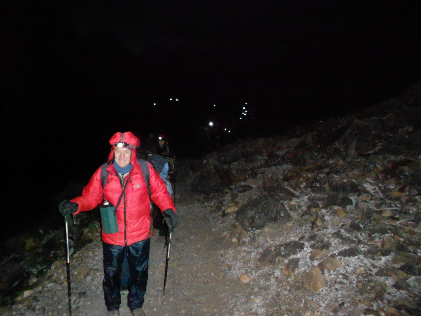
We had a miserable night.  The walls between our rooms were paper-thin and the raucous splutter of farts and throat clearing could be heard from as far afield as three rooms away.  Unrested, we awoke at four o’clock and climbed the trail to the crest of Poon Hill.  This, if the groups of puffing trekkers were anything to go by, was an ordeal for most.  For us however, having recently descended from 5500 metres, it was a complete breeze and we were amongst the first to reach the summit.  

By 5.30am, the grassy hillock and observation tower was thronging with an excited crowd of nearly 300 people.  A great cheer went up as the sun peeped over the horizon and the clear morning air crackled with the ecstatic whirr of cameras.  As the veil of night lifted, we were treated to a nearly 50 kilometre long panorama that consisted of two of the world’s 10 highest mountains (Dhaulagiri 8172 and Annapurna at 8091m) and a staggering concentration of subsidiary peaks including Gangapurna, Annapurna II, III and IV, the Lamjung Himal – and the curiously shaped Machapuchare (also known as Fish Tail Peak).  Rising from the obscurity of the valleys below, the great white barrier of mountains seemed to float in the delicate morning light.


Besides the fact that we’d lived amidst this splendor for the last nine days, even we were impressed.

Monday 29 October 2012

Evacuation

If our journey around the Annapurna Circuit was a story of two chapters, we were about to embark on the second.  Meanwhile however, something about Tatopani didn’t feel right to me:  our hotel was exceedingly grubby and though our room had the first western toilet we’d seen in two weeks, this was badly clogged with the waste of a previous occupant.  A possible explanation for this filth was the presence of a spider of such gruesome proportions that, (if our own shock was anything to go by), had probably loosened the bowels of the pour soul who last used the facility.  The creature’s lingering presence would also have deterred any cleaning staff from coming in and sanitising the place.  Besides these horrors, the sweet, clawing smell of dope hung in the air.  Amidst the previous evening’s downpour, I’d caught glimpses of trekkers skulking in the shadows, the cherry red glow of burning joints illuminating cupped hands.

The first order of business the following morning was a visit to the village’s famous thermal baths – (“Tatopani” meaning “hot springs” in Nepali).  We were tempted to take a dip but quickly discovered that a horde of chattering locals had beaten us to it.  Scores of men and women of all shapes and sizes luxuriated in the steamy pools while others were vigorously soaping themselves under the showers.  We returned to our rooms to find Colin pacing the balcony, his brow furrowed with anxiety and lack of sleep.  Sandra had taken a turn for the worse.  She’d awoken during the night gasping for breath and, terrified that she might suffocate, had asked Colin to sit alongside her and ensure she did not doze off. Wrapped up in the depths of her sleeping bag, her face drawn and hollow, she looked terrible.

Nilgiri


We had spoken at length about the prospect of evacuation.  Many years ago a friend was airlifted from Namche Bazaar after his appendix burst.  For days we’d been seeing the red and white helicopters of the HRA flying rescue missions over the Manang district.  Though we never imagined any one of us would be contenders for a ride out, it was immediately obvious that Sandra was in dire need of help.  Once the decision was made, activating the rescue was surprisingly simple requiring no more than a single cell phone call.  

The end of Sandra and Colin’s trek now a reality, a certain gloominess descended.  The entire team including Raj and the three porters crammed into the Harris’ room to join in a final prayer and to bid a sad goodbye.  There was little purpose in hanging around and waiting for the helicopter.  Prem, coordinating the operation from head office in Khatmandu, said the chopper’s ETA was still at least 90 minutes hence as it was in the process of evacuating stricken climbers in the Everest region.  After final goodbyes the depleted team crossed the Kali Gandaki River and began the arduous two-day climb to the town of Ghorepani on the valley rim.


Sunday 28 October 2012

A white knuckle day

The temple at Muktinath is one of the most important pilgrimage sites in the world for Buddhists and Hindus alike.   The structure is also one of the oldest Hindu religious sites in the world and is held up as shining example of the harmony that exists between the two religions.  In the early 1990s, the town only had two hotels.  Today it has more than 15.  The growth is due not only to the rise of tourism but to the burgeoning number of pilgrims who visit the town from as far afield as southern India.  As we passed the temple the previous afternoon, I noticed dozens of motorbikes parked outside its walls.  They act as a shuttle service between the town centre and the sacred shrine and one often sees dignified Indian men and women clinging for dear life to the driver as the bike weaves its way up the dusty high street through the pedestrian traffic.

At breakfast I got chatting to a young English guy who we’d met back in Manang.  Jason had completed the trek from Thorung Phedi to Muktinath in 6 hours, including a 30-minute stop at the summit for tea.  He must have been supremely fit.  We were a far cry from this: our traverse from High Camp had taken our team nearly 13 hours and had exacted quite a toll physically.  The previous evening we’d thus agreed to proceed to Jomsom by jeep where we would travel south by bus to Tatopani.  Dreams of Annapurna Base Camp were now well and truly buried.

The decision also meant that we would be bypassing the ancient fortress town of Kagbeni, gateway to upper Mustang.  I was bitterly disappointed as I was eager to see the region’s unique geography and learn something of its legendary horse culture.  It would have been a poor man’s substitute for a trek into the fabled upper Mustang region itself – a highly sensitive and restricted area that very few people get to see unless they have a lot of time, luck and money.  The area is still, at least to some degree, shrouded in mystery and intrigue.  Politically, it was the setting for the last and tragic stand of the CIA funded Khampa Rebellion that sought to wrest control of Tibet back from China.  Culturally, many of its people continue to live under a highly conservative strain of feudal Bhuddism, very similar to that which prevailed in Tibet before the Chinese took over.  Ecologically, it is the last frontier for a variety of endangered terrestrial and avian species including the Lammergeyer and the Snow Leopard.  A two-week trek permit for this ecologically sensitive area is not only hard to secure but is currently priced at $700.  Visitors must complete a register of all consumables they are carrying in as well as show that they have sufficient butane canisters as an alternative energy source to wood.  Packaging for every item on the register must be checked back in with the authorities upon conclusion of the trek.

It was a short walk down to the western end of Muktinath where we joined the lines for a jeep to Jomsom.  While waiting, I examined a table of black, spherical rocks the likes of which I’d seen on sale the previous evening in the high street.  They turned out to be ammonite fossils, locally known as saligrams and considered by Hindus to be sacred symbols from Lord Vishnu.  The stones are kept in temples, monasteries and households while water in which they have been soaked is drunk daily.  They are also used ceremonially in marriages, funerals and house-warmings and the dying person who drinks saligram-steeped water receives absolution and the right to dwell with Vishnu for eternity.  This brazen selling of saligrams, particularly in such vast quantities, is not strictly compliant with Hindu tradition.  Moreover, when one considers the number of pilgrims and tourists who pass through, the impact which fossil harvest is having on the local environment must be significant.

Boarding the Jeep to Jomsom - everyone in picture crammed into that vehicle

Saligrams for sale in Muktinath

In order to fill our jeep, we’d mingled in the dining room of our hotel the night before and recruited trekkers who were as desperate as we were to take some weight off their feet for a day.  Our vehicle thus contained a motley crew of injured travellers and their retinue of guides/porters.  Amongst others, we made friends with an Israeli couple, Nadav and Dana Sherman.  Nadav, a developer for Google in Tel Aviv, was suffering from ITB after the intense downhills of the previous day and could barely alight from the vehicle without wincing in agony.  Dana’s knees weren’t much better.  Seven of us squeezed into the back of the jeep while the remaining 6 sat up front.  Crammed into this confined, tinny space and inhaling a nauseating swill of fine dust and diesel fumes, we rode the waves of motion sickness as the vehicle flip-flopped its way through the 1000 metre descent into the Kali Gandaki Valley.

Admiring the Mountain fastnesses of Lower Mustang - Kagbeni can be seen beyond the apple orchards in the distance

At a lookout point halfway down, we took a break.  Some retched uncontrollably into the bushes while others admired the stony immensity of Lower Mustang.  The river plain combined with its lush apple orchards and surrounding ampitheatre of snow-capped peaks and gravelly hills are so vast that the place almost swallows anything which ventures into its depths.  I felt desperately cheated to be seeing it so fleetingly.  I equally regretted our short stay in Jomsom, a clean and well-ordered town that rests in the shadows of the great Dhaulagiri group.  But we were in such a rush to catch our bus that there was little time to do more than have a quick bite to eat.
*
It is the work of a moment to look at the map and say: “it looks like we can take public transport down to Tatopani – and it shouldn’t take much more than half a day”.  The first time visitor should not be criticized for this:  the road, on the map at least, looks fairly straight and the distance appears short.  

But all this is to ignore the fine print of the contour lines, the seed, (once again in our case), for gross miscalculation.  You’d think we’d have learnt from our grinding ordeal on the trip from Khatmandu to Syange.  In truth, we remained howlingly naïve.  We thus blundered into our rest day blissfully unaware of the adventures that lay ahead of us – of the almost seismic shift in altitude between Jomsom and Tatopani (about 2600 metres over a linear distance of 40 or so kilometres).  Of the inconvenient fact that we were at the tail end of a particularly generous Monsoon and that the hills were as saturated as a wet chammy leather.  Of the woefully slim choice when it came to choosing public transport…

Nepali busses, besides their gay and garish exteriors, must surely rank amongst the most nefarious inventions known to man.  Egregiously maintained, their interiors have been built with the stature of the locals in mind.  On the way to my seat I counted (through painful experience), at least 6 points of interruption between the ceiling and my head.  Furthermore, the coaches have the most rudimentary of sound systems that pipe an incessant and grating cacophony of weird and wonderful Hindi and Nepali music into the cabin.  

Our bus trundled out of Jomsom at about 11 o’clock heading South into the ever-deepening Kali Gandaki valley to Marpha – where we stopped to buy freshly picked apples.  Marpha’s chief export is apple brandy and I was impressed by the town’s quaint distillery.  As we left Mustang behind us, the barrenness was quickly replaced by imposing stands of pine and juniper.  At three, we experienced the first disruption to our journey.  The road ahead was so bad we would have to disembark, retrieve our luggage from the roof and hike two kilometres to the next town where we would find another bus.  Everything about this changeover seemed fairly routine until we got caught in the mad scrum to board the new bus.  Let’s just say it nearly got violent.

Apple stop at Marpha

Bus change in the Kali Gandaki - The World's deepest Gorge

The second bus journey was a terrifying ordeal.  Though a considerably shorter leg, a vehicle designed to hold no more than 30 passengers now held upwards of 60.  Moreover, the road now descended into the business end of the world’s deepest river gorge.   Often hideously close to the void, our bus seemed to defy the laws of physics as it hared through the bends and switchbacks.  When we disembarked half an hour later I noticed that one of the back tyres had shrugged off its re-tread and was down to the canvas.

What you see here is not dirt but canvas

The relief of terra-firma was short-lived however.  It was nearly five o’clock and the last bus of the day was due to leave the next village in 20 minutes.  If we missed that, we would be forced to camp in the open.  This triggered a desperate footrace through the gorge in which all 70 passengers of the previous bus participated.  The field arrived in the next hamlet more or less as one though just in time to see the bus in question disappearing around the next bend.  A collective groan rose above the village though hopes were restored somewhat when a local trader said he thought another bus would be through at any moment.  

An hour later we were still waiting.  The crowd slowly thinned out as locals returned to their houses and a few trekkers shouldered their gear and headed off down the road to the next village.  We said goodbye to Nadav and Dana.

At 6.30, just as we were entertaining thoughts of our own night hike, a jeep in hideous state of disrepair laboured noisily up the hill.  There was a grinding of gears as it stopped in front of the store.  As the driver emerged, Raj flew hastily into action.  After an animated conversation our guide and the driver disappeared around the corner for a few minutes.  I cannot say what went on there but I imagine a lot of money must have changed hands.  Ten minutes later, the jeep was loaded and we were ready to go.  A pair of young Israeli girls joined us, one of who was suffering from a ruptured eardrum.  We left the settlement much relieved.

As is usual with the roller coaster nature of road travel in Nepal, there were more thrills in store.  I peered through the windshield, seriously obscured by tassels, trinkets, carpeting and stickers of Bollywood actresses.  The night was closing in quickly and visual perception for the next hour would be confined to opportunistic glimpses, mostly as the vehicle tilted to one side.   What I do remember was a waterfall so colossal that I thought I was hallucinating.  If it weren’t for Martin’s cry of amazement at seeing the same thing I would still think it a mirage.  Will I ever behold such an awe strickening sight again I wonder?  It consisted of at least 4 separate cataracts, the last of which thundered into a pool through which the road passed.  From there, the river turned downhill and followed the road.  We drove with water up to the wheel bolts for nearly a full kilometer.

View from the front seat of our jeep

Just as it got pitch dark, our driver stopped the car, turned to me and said: “I’ll on the lights!”  Why, I wondered, the need to stop the car?  It turned out that the lights in question had to be actually fastened ON to the car.  A roll of masking tape was produced and our porters got out to offer advice.  One of our Israeli friends commented that on a previous jeep ride in Chitwaan Game Reserve, the headlights had been so weak that the driver asked his passengers to climb onto the roof and use their headlamps to light the way.  At least in our case it never came to that.

At 8 o’clock, the jeep stopped in the midst of a heavy downpour outside our lodge in Tatopani.  We were too tired and shell-shocked to even feel relief.  At 1100 metres, we were now firmly back in the tropics.  The air resounded with the shrill chirruping of cicada beetles and the angry roar of the river.  The contrast with the past five days was surreal.

Three hours later a bus descending from the village of Rupsecchhahara (where we’d commandeered our jeep) failed to negotiate a decisive bend in the road and sailed headlong into the inky darkness of the Kali Gandaki.  Miraculously the occupants, a driver and his conductor, escaped with their lives.

It could so easily have been us.


Friday 26 October 2012

The Thorung La

Though 5416 metres above sea level, the Thorung Pass is sill about 400 metres lower than Kilimanjaro.  In spite of this the climb has its unique challenges, the biggest of which is the profusion of “false summits” that play havoc on the trekker’s morale.  The stone halfway house one encounters at dawn for example, looks very much like the structure at the summit though it is still several hours shy of it.   In addition, the undulating hillocks and saddles are so shapeless and void of definition that one can easily become disoriented.  Indeed, I have only dreamlike memories of that morning. 

In an attempt to assess ideal fitness requirements for this leg of the circuit, I had spent hours sifting through online reports and blog postings of people who had done it.  Much like the endless speculations that circulated on how to deal with altitude, I found there was no consensus on the toughness of the climb or just how much physical training was required for it.  Some younger, fitter trekkers minimised the physical demands while others – lulled into a false sense of security by their fitness levels - had gone too fast and found the day torrid.  Older trekkers had a more sober-minded approach and while they made no bones about the toughness of both climb and subsequent descent, they at least made it sound possible.  With hindsight (but with plenty of training behind me), I would describe the traverse of the Thorung La as challenging but fun.

A 3/4 moon hung high in the western sky as we fell into the shuffling procession of trekkers heading up the pass.  There was none of the cheerful banter that characterized the previous mornings, instead only laboured breathing and the squeak of boots on powdery snow.  The moon cast just enough light to pick up the faint outlines of the neighbouring peaks but to stay on track the use of a headlamp was essential.  When I stopped at the top of the first rise to look back, the bobbing line of tiny lights looked like a giant Christmas decoration on the move.  This was the first time in days that our team walked as a unit, checking on and encouraging one another, each reminding the other to drink.

The smiles didn't last much beyond sunrise!

Memories of the four-hour climb, such as they were in that shapeless moonscape, have collapsed into a vague though heady collection of highlights: golden clouds boiling up darkened valleys, coppery mountain peaks penetrating the milky predawn darkness, desolate boulder strewn draws encrusted with snow.  Two hours out from High Camp, the procession had fragmented somewhat and for extended periods, we walked in solitude.


Soon however, our slow and fairly deliberate pace seeded us with a number of trekkers that were more or less in our age group or fitness level.  Most were struggling but were philosophical enough to know that the strain could be leavened by a liberal dose of humour.  Occasionally we would encounter someone who was clearly suffering from mountain sickness.  One such person was a Chinese lady who had become separated from her husband and who was staggering upwards, heavily burdened with camera equipment.  Possibly because of the language barrier but maybe because of delirium, she was impervious to our encouragements to rest and drink.  One got a slight insight into the heart-rending dilemmas faced by climbers in the Death Zone who can do little or nothing for ailing comrades.  While I would never say that 5400 metres warrants an “every man for himself” attitude, helping a sick person without compromising one’s own chances would have been very difficult indeed.  Mercifully, the Chinese lady prevailed and seemed to be doing fine by the time we reached the summit. 

One person who wasn’t doing well was Sandra.  By now she was quite unresponsive though complained periodically about a cracking headache.  At one point, on hearing that the summit was still two hours away, she had sat down in the snow and wept with frustration.  Thus, when we reached the summit at about 9am, we resolved to make our stay as brief as possible.  

There was a certain elation associated with getting to the top…countless photos were taken interspersed with plenty of high-fiving.  Afterwards, we crammed into a small stone house for a hot cup of tea.  Judging from the number of customers, I imagined the owner was making a small fortune from this venture.   But the place was so crowded, the smell of gas so overwhelming, I made a claustrophobic dash for the door.  It was pretty cold outside: twenty minutes later when we were getting ready to leave, I discovered that the pipe of my Camelbak had frozen solid.  We also discovered to our horror that someone had stolen Martin’s trekking poles, a disaster considering that the worst part of the route still lay ahead of us.  In light of Martin’s knee injury, the implication was that one of us would have to surrender our own poles.  As the crowd of summiteers thinned out however, it appeared it wasn’t a case of theft after all but rather one of mistaken identity.  We took a seemingly unclaimed set and after checking that the owner was nowhere, appropriated them.  This was a huge mercy – without them the walk down would have been close to impossible.

The summit at last - from left Rissam, Ram, me, Raj - kneeling is Kisna

I started this piece claiming that traversing the Thorung La was “challenging but fun”.  As we began our descent, it quickly became clear that the fun part was behind us.  While blogs described the descent as tough, many were quick to point out that it was a lot better than negotiating the pass in a clockwise direction i.e. from Muktinath to Thorung Phedi.  Only two categories of people, it seems, do this – local traders on horseback and the certifiably insane.  One reason is the absence of any suitable lodgings so acclimatization is nearly impossible.  Another reason is the unrelenting steepness of the path.  If the descent seemed endless, I shudder to think what the 1500m ascent might be like.

A look back up the trail
Buoyed up by the euphoria of having reached the summit, we began the walk down in a cheerful mood.  It wasn’t until midday however that the desperate nature of the retreat began to dawn on us!  Though the snow gradually thinned out and the pathway became less slippery, the steepness intensified.  We took a rest on a remote pasture, a brief “landing” in the unending staircase of switchbacks.  From this vantage point, we looked down into the arid swathe of the Kali Gandaki Valley, to Muktinath and Kagbeni, gateway to the fabled region of Mustang.  In the distance stood the imposing bulk of Dhaulagiri, the world’s 7th highest mountain.  

Our destination still seemed miles away.  And though we’d descended at least 900 metres, the dangers of altitude had not diminished in the least.  High on the path above the meadow, I watched Lil staggering downwards, retching uncontrollably, clutching her head and complaining that she must have caught a bug.  Had we been more attentive to the talk on AMS at Manang, we would have known that many cases of altitude sickness present several hours after leaving the summit.  Also, we would not have lingered in this exposed position.  Ignorantly however, we sat around for nearly an hour trying to get Lil to swallow Super C’s and headache tablets.  Imagining that he would be welcome the money, we asked a passing horseman if he would escort her down on his pony.  Strangely he was hesitant – the path was too steep and either she would fall or the horse would stumble and hurt itself.  Instead, the man opened his bag and produced a bread roll.  “Perhaps if she eats she will feel better”, he said in Nepali.  We declined but were touched by the simple gesture.  With Martin, Sandra and Lil on the brink of exhaustion, we redistributed their packs between the three of us and resumed the bone jarring descent, stopping only to eat at a grimy establishment in Charabu.  A photo taken there shows the sorry and mostly humourless state of the team.

This section of the descent was probably the toughest - the path was surfaced with stones the size (and shape!) of a rugby ball and played havoc on the ankles

A humourless lunch at Charabu

By now I was impatient with our slow progress and itching for a hot shower.  After lunch I shouldered the packs and powered down the slopes.  As I approached a suspension bridge over the Thorung River, I saw Ram, Rissam and Kisna moving up the slope towards me.  Earlier that day, they had rushed on to Muktinath to secure hotel rooms.  Now, freshly showered and dressed in casual clothes and flip-flops, they were retracing their steps to help us down the mountain.  It must have been a tough day for them too but they were showing none of the outward signs.  A half hour later I was luxuriating in a hot shower at the North Pole Hotel in the sacred town of Muktinath, a sublime relief after 5 days of not bathing.  Two hours later, the rest of the team limped down the high street – shaky but in fairly good spirits.

Martin and Lil limp into Muktinath, sans luggage

That night, we celebrated the crossing over a meal of sizzling Yak steak and a shot of the region’s famous apple brandy, served hot alongside a cup of ginger tea.  It was a memorable end to an even more memorable day.  In truth, it was a half-hearted celebration.  The pass had taken its toll and it was doubtful we could proceed with the journey as planned.

Thursday 25 October 2012

To Thorung Phedi and High Camp

The three days from Manang to High Camp were characterized by a series of relatively short treks, punctuated by long periods of inactivity at our destinations.  While the “rule of threes” prescribed an ascent of no more than 300 metres a day, the contour interval between settlements made adherence to this tricky.  Fortunately, trekking time was now truncated to no more than 5 hours a day (at worst) though in places the physical exertion was even higher than it had been on day two.  I found negotiating suspension bridges a particular challenge.  Setting a rhythm on the trail proved relatively easy – a simple plod stabilised by ones trekking poles ensured minimum expenditure of energy.  But bridges were another matter.  For one thing, they had a tendency to sway just enough to knock one off one’s rhythm.  For another, the “downhill” part of the traverse was soon followed by a curiously taxing incline that sapped the lungs and made the muscles smart.  Invariably, the exits to suspension bridges were bottlenecked by heaving pelotons of huffing, puffing trekkers.
  
Typical dwelling of the Manang area - wood is piled up on the roof in anticipation of winter.  Such piles are an outward sign of wealth, prestige and status in the community

Travelling above the tree line, we now beheld a form of alpine desert where the rocky ground sustained little more than a species of coarse grass (upon which the Yaks and Musk Deer graze) and a ubiquitous thorny scrub called Seabuck Thorn.  The plant bears a perennial orange berry that is said to contain the highest concentration of vitamin C and Lycopene in the plant kingdom.  This fruit is painstakingly picked, mashed to a pulp and strained by hand to distil a bright orange juice.  The splendid beverage is served hot to thirsty trekkers and is the closest I’ve seen to magic potion.  Three days later after the harrowing descent from the Thorung La to Muktinath I sampled a cup and felt the life returning with almost every sip.  My only regret is that I didn’t discover its life giving properties sooner.


Men churning Nak milk

Yak Meadow near Gudrung

Tea break with Gangapurna in the background

Dutch trekker Sander and his guide Tilak

Another memory of this leg was the increasingly spartan nature of the villages we encountered.  Lodges were increasingly exposed to the elements and we quickly layered up against the escalating cold.  Upon arrival, we would eat lunch and then rest up on our beds, reading and chatting.  Though the morning weather was invariably pristine, afternoon activities might be curtailed by low-lying cloud, high winds, sleet and in places, light snow.  The enveloping cloud had a distorting and spooky effect on sound too.  The soporific clanging of bells announced the occasional passing of yak, pony or donkey trains and occasionally the mournful cry of a Yak grazing high up amidst the gloom jerked one from one’s slumber.  

Whiling away the time

Men and Ladies Toilets - denoted by the skulls over the doorway

At lunchtime of Day 8 we arrived at Thorung Phedi, Nepalese for “The foot of Throung Mountain”.  This remote base clings to the edge of a lonely but spectacular gorge containing the Kone River.  The river was a mere trickle at this time of the year but judging from the high water markings had the potential to be a thundering behemoth in spring.  To get to Thorung Phedi we had to negotiate a tricky landslide belt through which the ribbon like path intersected towering, flinty screes.  A fall here might not have been fatal but it would have put an end to one’s trek.  Indeed, one of Sandra’s ward mates in Kathmandu was an Australian who’d fallen while taking a pee one night.

Entering the Landslide belt at Thorung Phedi - it took an hour to walk to the point where the path disappears in the distance

The barren outpost of Thorung Phedi

The dining room at Throung Phedi was a hive of activity.  Because there was little else to do (and the bedrooms were spartanly furnished and cold to boot), complete strangers came together over endless games of cards and chess as well as discussions about reading material, philosophy and politics.  From about lunchtime to 10 o’clock at night, there was no rest for the long-suffering kitchen staff who ferried a constant stream of steaming meals and hot beverages to hungry trekkers.  I was impressed at their efficiency in spite of the most rudimentary kitchenware.  While not fine dining, meals were completely wholesome and mostly delicious.  Anything containing pasta, tuna, rice or potatoes was in high demand and noodle soup was ladled up by the gallon. 

The owner of the place struck me as a fairly urbane fellow having installed an advanced sound system in the dining room which, linked to his iPod, played such artists as Bob Dylan, The Rolling Stones and Eddie Vedder.    He also owned a dog of non-descript breed that he lovingly referred to as “Puppy”.  The dog is one of the most photographed and videoed animals in the region and thanks to YouTube, I knew all about him months before leaving home.  Though 15 years old now, “Puppy” is famous for accompanying trekkers over the pass and staying with them as far down the other side as Muktinath.  In his old age, his fur is terribly matted and a veritable treasure trove of burrs and Seabuck berries.  Still, he seems content and is universally loved by trekkers.

Mountain Dog

The main topic of conversation between trekkers however, was on the best strategy to traverse the Thorung La.  Was it better to climb the 1000 metres to the summit in a single day, followed by the 1500m descent to Muktinath?  Or was the more prudent option to ascend 850 metres to High Camp, sleep there and then attack the pass?  Surrounded by hundreds of opinions from people who’d never done the trek before, I discovered quickly that there was no right answer.  What helped swing it for us was the fact that option 1 is generally regarded as an 8-hour walk.  Take our persistent defiance of gazetted walking times, couple that with the effects of the cold and altitude – throw in the fact that at least half of our team was the walking wounded - and it would be quite possible that the journey from Thorung Phedi to Muktinath would become a grim fourteen hour route march.  There was no choice but to stay at High Camp.

The dining room 

Next morning, the real climb began in earnest.  On a straight line, the distance from Thorung Pedi to High Camp is probably no more than a kilometer.  But in the Himalaya, only a debutante measures distances in kilometres.  Though the climb was only meant to take 45 minutes, we took plenty of water breaks and did it in 90.  We were also blessed with a sighting of a herd of musk deer, an increasingly rare sight in these hills.  The weather turned early that day and we arrived in the dining room of High Camp just as it began snowing.  As was the case in Thorung Phedi, we spent most of the day socializing in the dining room over hot drinks and food.  Early that afternoon, I joined Raj and an American trekker named Fred on an acclimatization climb to a nearby viewpoint.  From the top, we looked down a full vertical kilometer to the lodge we’d slept in the night before.  By now there was no greenery at all – High Camp, a forlorn pinprick in a moonscape of bald, serrated hills, snow-clad mountains and frigid glaciers.  

Thorung Phedi from High Camp - 400 metres below

It was cold - High Camp far below

This, for me, was the real Himalaya and I was exhilarated to be up this high.  Though I may never climb to the treacherous heights of an eight-thousander I felt for the first time that I’d earned a small place in the great mountaineering stories I used to devour as a kid.
*
I woke up to the muffled clanging of horse bells outside my room.  The door creaked open as Martin returned from a trip to the toilet.  I looked at my watch:  3 o’clock.  Time to get up.  Our bags were mostly packed so getting ready was merely a question of stowing our sleeping bags – (we’d slept in our clothes to avoid the fuss of dressing)

“It is very cold tomorrow” Kisna had prophesied in his broken English when he said goodnight the previous evening.  And he wasn’t wrong.  In fact, it was already snowing.  After a nervous breakfast of oats porridge, we adjusted our headlamps, said a quick prayer and began the march to the summit.


Wednesday 24 October 2012

Rest Day in Manang

We were entering what I consider with hindsight to be the most photogenic crescent of the Annapurna Circuit.  What struck me was not only the sheer diversity of the subject matter but the density of it too - strange and fantastical geological formations, wooded valleys of blue pine and juniper, serene meadows, artisanal wooden bridges spanning rushing rivers.  All this scenic generosity juxtaposed against cobalt blue skies and boiling phalanxes of cloud made the memory of our third day one I will treasure for a long time to come.  


Trekking near the Swargadwari Danda - the photos hardly do this place justice

At the epicenter of this marvelous region was the village of Dhikur Phokhari, immediately recognizable for the gigantic sweep of the Swargadwari Danda – a severe rock face which towers over the town.  It resembled a gargantuan tidal wave which aeons ago was on the verge of pulverizing the valley before the creator uttered the words “this far and no further”.  The 1500 high metre wall was visible for the majority of the walk from Koto to lower Pisang though some of the best views could be seen from the road that meandered through the forest beyond the town.

The day would have been perfect except for the fact that I had a pounding headache by the time we reached Pisang, 3200 metres above sea level.  I made a mental note to escalate my water intake and to commence my course of Diamox that very night.  After checking into the guesthouse, I followed the trail out of town to get a better view of the sunset.  I stood for a while and examined a primitive yet fully functioning aqueduct fashioned from hollowed out pine logs.  It was brimming with fresh water diverted from the river higher up the trail and though ancient was undeniably elegant in its simplicity.  I crossed the river and scrambled up the hill.  On the crest stood a memorial to an ill-fated Japanese expedition that had perished some years ago on the slopes of Annapurna IV.  High above the forest, the peak in question luxuriated in a glorious burst of alpenglow – almost too beautiful to be dangerous.


Dusk outside Pisang

That evening in the dining hall, it was obvious that I wasn’t the only one concerned about the effects of altitude.  Indeed, the higher we got the more fixated about it we became.  We were unanimous that the trail had been harder than anticipated and keenly aware that our progress had been painfully slow.  Stretches which should have taken 6 hours or less to complete were taking 8 hours or more.  But it wasn’t until Raj said that we would need more days to successfully negotiate the Thorung La that things really got really heated.  Some lamented the obvious implications: the trip to Annapurna Base Camp would either be an unpleasant rush or even impossible.  After much debate on how to reset our itinerary, we agreed not to re-visit the issue until our rest day in Manang.  Of one thing we were all agreed however: no one wanted to retrace the trail to Sangye.  There would be only one way and that was up.


The following day, the walk through to Manang was one of the most relaxing we had had to date though conditions were very dusty and the glare off the road’s clay surface intense.  Much as I enjoyed the day, I was irritated to discover when it was too late that there were two routes to Manang and that our guide, assuming we weren’t fit enough for the higher more scenic one, had remained silent on the issue and defaulted us to the tamer route.  It was a Swedish Doctor we met near Humde who let the cat out of the bag, expressing amazement at our choice.  Though she didn’t elaborate, we knew we’d drawn the short straw.  Still, had it not been for this, we would not have been in a position to sample the baked delights of the Humde and Manang valleys where the locals have developed quite an expertise in the fine art of patisserie.  At Humde airstrip we purchased cinnamon buns from an old lady by the roadside and at Braga sampled freshly baked carrot cake.  These items were surprisingly good and a welcome break from the artificially sweetened biscuits that up to now had accompanied our tea breaks.

The Humde Valley - the airstrip is temporarily out of action as they are tarring it - (probably bad news because it will mean more flights and thus more tourists)

Making friends in the Humde Valley


 We arrived in Manang shortly after lunch.  At 3500 metres, the town is a good place to spend a rest day and most trekkers spend two nights there.  Because of this, Manang is a good deal more cosmopolitan than other places we’d stayed.  The cobbled streets are lined with souvenir shops, outdoor stores, book exchanges and a few very good coffee shops and bakeries selling such brands as illy and Lavazza.  The town even has its own movie house that constantly loops the same 6 films.  They are:

“Into the Wild” and “Into Thin Air” (inspired by the John Krakauer books)  
The Nepalese art nouveau classic “Himalaya”, 
The gripping mountaineering docudrama “Touching the Void”, 
“Slum Dog Millinear” (sic) and 
“The Hangover” (of all films!).  


The movie house has its own fireplace, seats covered in Yak hide and guests are served fresh popcorn and hot tea.  It’s all a very nice touch indeed.  Manang is also the headquarters of the Himalayan Rescue Institute, housed in a ramshackle cottage at the entrance to the village.  Here, trekkers can attend free daily talks on mountain sickness and have their oxygen levels tested for $10 a pop.  We attended one such talk and found it both highly informative and entertaining – if not a little unnerving.  

After a good night’s sleep and the prospect of a full day’s rest, everyone was feeling a lot better.  I went shopping and bought trekking poles having neglected to get some in Khatmandu.  Eager to try them out, I convinced Raj and the others to join me on an acclimatizing walk up to Chongkor Point (3800 metres) on the other side of the river.  The point is at the summit of a massive hill that overlooks the Gangapurna Glacier and lake.  

Led by two of our porters, we set off just after breakfast.  The downhill section to the river led through Manang’s primitive stone town where the sanitation was gossamer to say the least.  I quickly named this septic area “poo alley”.  Fortunately the uphill section to Chongkor point was a lot easier than it looked from the other side of the valley and though the views of the glacier and the lake were spectacular, they were alloyed somewhat by the prospect of the descent.  No one was looking forward to a knee pounding – or to the miasmic sludge of “poo alley”.   But in the event we coped just fine.  

Technology comes to the Annapurna Region

Gangapurna Glacier

Amongst Manang’s many acclimatization walks is an excursion to a monastery situated on a barren hillside 800 metres above the village.  The place dates back to mediaeval times and is inhabited by a Buddhist Lama who for the sum of 200 rupees will impart a blessing to his visitors.  A fellow trekker who went there told me that the Lama is 94 years old and that he last came down to Manang more than 30 years ago.  He is attended by his 64 year old daughter who descends to the town once a week to purchase food and other supplies.

The rest day did me good and and though Manang was a bit on the busy side and our hotel a little too grubby for my liking, I found the valley enchanting.  In the rarefied air, the mountains seemed so close you could reach out and run your hand along their icy slopes.  I was also taken by the industriousness of its people and the “all hands on deck” urgency they brought to harvesting the ripened wheat crop.  From before sun up to well after dusk, people of all ages pressed into the challenge associated with cutting, bundling, carrying and threshing.  I suppose the spectacle should have inspired a sermon on Matthew chapter 9!  

The only concern was Sandra’s condition.  Her flu had actually gotten worse in spite of her day’s rest.  Surprisingly, a British doctor form the Himalayan Rescue Institute had given her the all clear to ascend, providing she did so slowly.  Our decision regarding itinerary had practically been made for us.  Our next overnight stop would be Yak Kharka, 400 metres higher than Manang.

The beautiful Manang Valley